%20(1).png)
Local plans shape investment, infrastructure and development patterns for decades to come. They are evidence heavy, politically sensitive, and delivered by teams working under tight budgets and limited capacity.
That is why the move to a 30-month plan process cannot be met by simply doing the same tasks faster. For many councils change is needed in how information is gathered, assessed and presented, under the new plan system.
The Government’s new guidance makes 'digital-first' an explicit expectation, alongside using standardised assessments and resources. 'Digital-first' is not about bolting-on another platform at the end of your pipeline of work; it is about reducing avoidable friction in your core plan-making workflows so you can keep momentum and spend more time on important human-led planning judgements and evidence-based decisions. A 'digital-first' approach protects scarce officer time by reducing manual admin and rework. It can also help councils keep more routine analysis and reporting in-house, reducing reliance on external agencies for standard outputs.
At Urban Intelligence, we're already working with PlaceMaker councils who are embarking on the new 30-month system: streamlining processes, implementing compliant standardisation and supporting planners to meet the demands of the new system. With our in-house planning and tech expertise, we're supporting councils who are digitally advanced and those just starting out on their digital planning journey.
Want to discover what a 'digital-first' approach would look like for your local plan? Below are a few practical examples and how PlaceMaker is designed to empower and support planners just like you, through the new plan system:
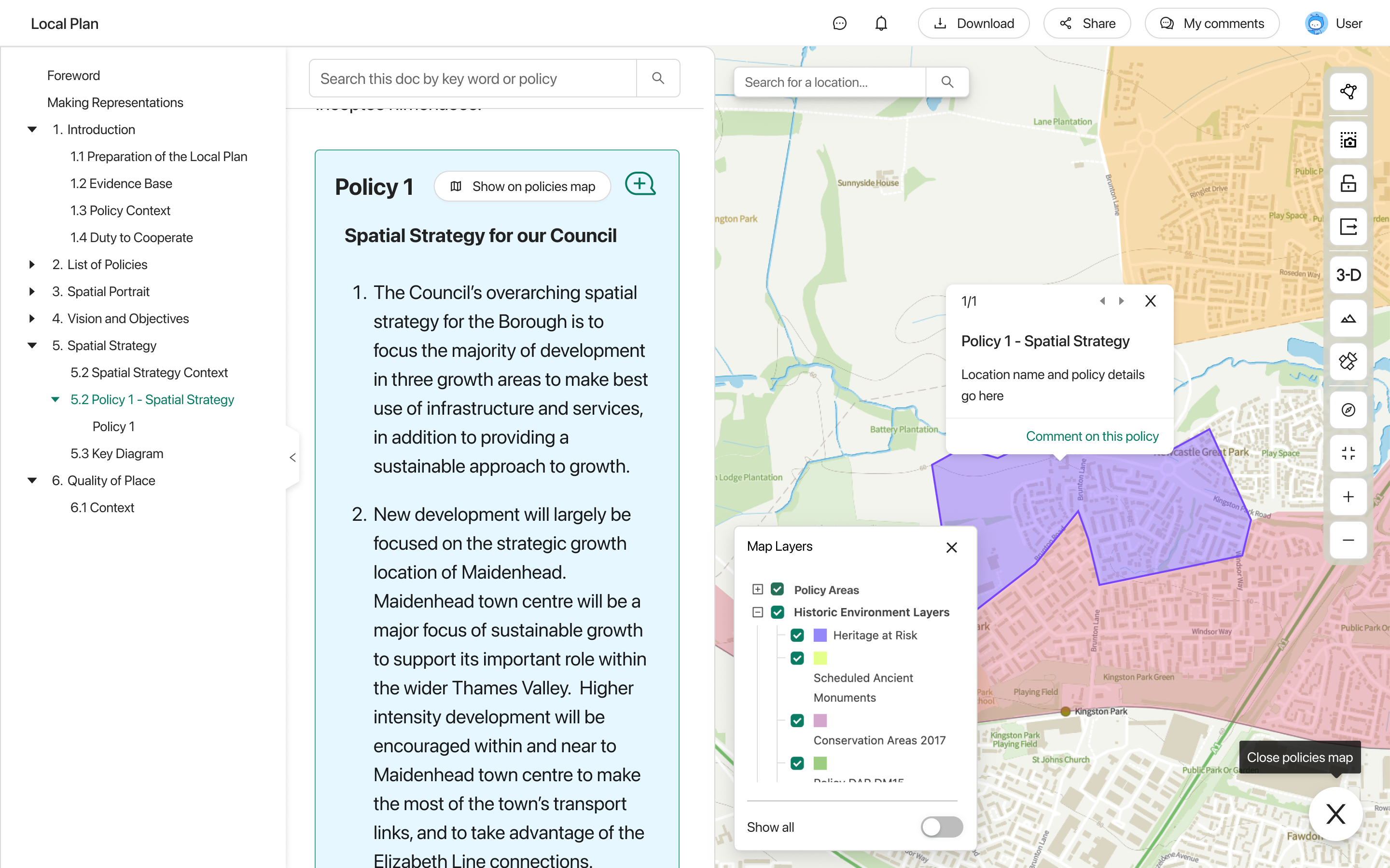
PlaceMaker provides the ideal home for all your local plan policies and data. Centralising your baselining data, including pre-loaded national data sets, for early site identification and assessment. Public web map capabilities also allow you to present your spatial data publicly with key stakeholders, allowing them to see key data about their place for engagement and transparency.
Site Identification is key even before the 30-month timeline commences. In PlaceMaker you can carry out site identification with simple or complex spatial queries, add in officer drawn custom sites or carry out digital Call for Sites exercises with compliant and consistent data collection. New guidance for site identification recommends online Call for Sites forms and sets an expectation for digitally mapped submissions.
.png)
PlaceMaker has already helped councils across the country receive thousands of digital Call for Sites submissions. The platform adds the submitted site data straight into a centralised database ready for officer assessment. With required data fields for the 30-month system templated in PlaceMaker, this digital Call for Sites process is both easier for planners and a smoother user journey for those submitting the sites. The public web map feature also allows planners to proactively share submitted sites with the public, typically reducing inbound queries about submitted sites from the public.
The updated guidance sets out that assessment should incorporate quantitive evidence and professional judgement, while arriving at consistent, clear decisions. PlaceMaker's site assessment workflows can support planners to assess existing, submitted and officer-drawn sites with guidance-compliant methodologies, from initial suitability sifts to more in-depth assessment and officer judgements.
Once identified and assessed, PlaceMaker's site lists enables planners to categorise and organise sites, to inform emerging spatial strategies and decision-making on types of development opportunities. This data can then be used in PlaceMaker's dashboard feature (coming soon) allowing planners to visualise and monitor progress.
In practice, faster site work comes from consistency and scalability:
Publishing a map of proposed Local Plan policies is now a suggested step during Gateway 2 of the new plan guidance, and a full policies map is now required within one month of plan adoption at the end of the 30-month process. The guidance also provides recommended standards for how a policies map should be presented, including how policies should be categorised and the visual approach to themes and symbology.
A 'digital-first' approach in PlaceMaker allows you to bring together all the core elements of your Local Plan, in a digital format, enabling you to iterate throughout the plan-making process, and at the point of adoption. By centralising all your relevant plan data into one platform, you are able to create a visual map of policy data at any required stage, for transparency and to enrich public engagement.
In PlaceMaker's document builder you can make use of templated documents from your Notice of Plan Making to Self Assessment Summaries, as well as creating engaging consultation documents and a full digital Local Plan document with map-linked policies. Integrating all you site data with document creation enables the easy incorporation of maps, charts and tables into you consultations and reports. Not only can site data be linked to these public-facing documents, but representations received through consultation can then be linked back to your centralised database, linking comments to sites and policies for efficient analysis.
We understand the challenges that the new system presents to councils. However, as digital planning experts, we also see the opportunities for digital tools to enable this transformation. The new guidance enables greater standardisation, unlocking opportunities to build consistent evidence bases at a faster pace.
With over ten years experience working with local government planners, our digital platform is purpose-built for the ever-evolving Local Plan process. PlaceMaker provides the end-to-end infrastructure for your 30-month process including site identification, assessment and engagement - producing a truly digital local plan.
If you would like to discuss how PlaceMaker can support your council through the new plan system, book a call with our experts today. Our PlaceMaker demos are presented by planners, not sales people, so you can speak with our expert team about your lived experience as plan-makers and discuss your requirements for creating a 'digital-first' local plan and taking the next step on your digital planning journey.
Our demos are delivered by planners (not sales people) they’re no obligation and it can take as little as 30 minutes
Book Demo
